9-14 FB Space Inspection
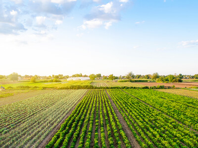
Examine your crops and fields from afar, and I mean really afar. From space.
I have a good friend who is a wheat farmer up in northern Idaho. He is a very high tech guy… In fact so high tech that he teaches technologies evolving in agriculture at the University of Idaho. He designed what I would call a little drone that is intended to fly over crops and is mounted with high-resolution cameras. End of story, he is using this drone to find out the status of his fields in terms of irrigation, nutrition and weeds. His problem has been that he gets into all kinds of rules and regulations with the FAA because of height restrictions etc. We even flew together to Los Angeles to meet with an entrepreneur about how we could commercialize this venture. Well, guess what. Satellite technology has entered the picture and I will let Norm Davy, senior vice president of GEOSYS, Inc. tell you the rest. “We can actually get imagery for the greater part of the United States agricultural growing regions and be able to acquire that imagery, process it and upload it into a platform that would be made available with a 2 to 3 day delay from when it is acquired and then made available to farmers through their retail agronomist where they can look specifically at the imagery and from that imagery can understand if there are parts of the fields that are doing extremely well and if there are parts of the field that are not doing so well.”